%20(Beta)%20(2).png)
Features
Simplify How You
Plan Adventures
Planning a trip should not mean bouncing between apps just to piece things together.
Camps in one place, trails in another, food somewhere else. It slows everything down and breaks the flow of the experience.
TACOVENTURES brings it all into one map so you can see what is around you, understand your options, and make decisions without second guessing.
.png)
No payment required
.png)
Ad-free
No distractions
.png)
No region downloads
.png)
No clunky interfaces

.png)
All Adventure.
One Map.
NO SWITCHING BETWEEN APPS
-
Camps, trails, POIs, food & more in one map
-
See what’s around you instantly
-
Pins show exactly what each spot is
TACOVENTURES brings camps, trails, food, and key stops into one clean map so you can stop piecing trips together across multiple apps. Everything is structured to give you clarity at a glance, whether you're planning ahead or already on the road.


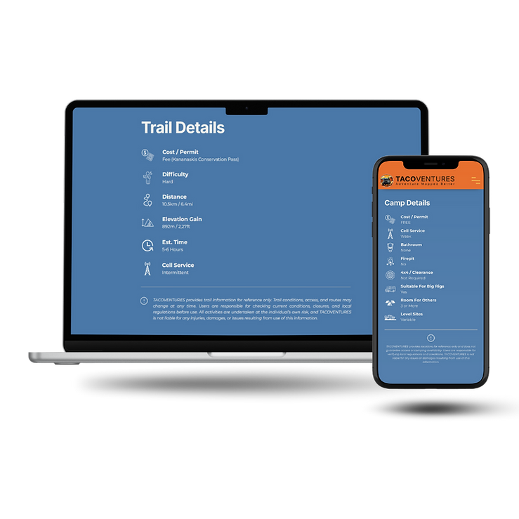
Know Before You Go
NO SURPRISES UPON ARRIVAL
-
Access, type, and status at a glance
-
Know if it’s free or requires a permit or fee
-
Only the details that matter
Every location is designed to answer the questions you actually have before arriving. Access, requirements, and key details are surfaced immediately so you can avoid wasted time, wrong turns, or unexpected restrictions.
.png)

.png)
Plan Faster.
Move Smarter.
STOP GUESSING. DECIDE FAST
-
See key details instantly
-
Know if it’s worth the stop
-
Decide in seconds
Instead of digging through reviews or guessing from scattered pins, TACOVENTURES highlights only what matters. You can quickly evaluate a stop and keep moving without second-guessing your decisions.

Real Visual Context
NO GUESSWORK—SEE IT FIRST
-
See the real setup before you arrive
-
Aerial views for full perspective
-
Know the vibe before you get there
Photos and aerial views give you a clear understanding of what to expect before you arrive. No more guessing based on vague descriptions or outdated images — you can see the setup, space, and surroundings in advance.
.png)

.png)
Directions,
Simplified
START MOVING INSTANTLY
-
Open in Google Maps or Apple Maps
-
Coordinates ready for offline use
-
One tap to navigate
Once you’ve found a spot, getting there is immediate. Launch directions in your preferred app or copy coordinates for offline use, making it easy to navigate whether you're in service or off-grid.